The Nuevas Poblaciones de Andalucía y Sierra Morena project began around 1767, during the reign of Charles III. It was an Enlightenment project drawn up by Campomanes and entrusted to Pablo de Olavide, which sought to populate certain fairly extensive areas that had been depopulated. These lands were located along the Royal Road of Andalusia that connected these lands with the plateau (central peninsular), and included the desert of Sierra Morena or La Peñuela (Jaén); the desert of La Parrilla, between Córdoba and Écija; and the desert of La Monclova, between Écija and Carmona. The idea of populating these lands had the intention of improving the safety of the people and goods that moved through them, which were mainly threatened by banditry. To bring the project to life, Catholic settlers from central Europe, mainly Germans, Flemish and Swiss, were attracted and provided with land to promote agriculture and industry. These new settlements were known collectively as the “Nuevas Poblaciones” (New Towns), and had their capital at La Carolina and La Carlota.
Collection: Images
Project: 3. Rural world and urban world in the formation of the European identity.
Chronology: XVIII
Scope: Baccalaureate, University
Link: http://www2.ual.es/ideimand/portfolio-items/plano-nuevas-poblaciones-de-sierra-morena/
Resource type: Image
Format: Imagen digital
Source: Proyecto “Identidad e Imagen de Andalucía en la Edad Moderna”. Universidad de Almería. Fondo del Archivo Histórico Nacional. INQUISICIÓN, MPD. 274.
Language: Spanish
Date: 9/28/2020
Owner: María del Mar Felices de la Fuente (Modernalia)
Identifier: Archivo Histórico Nacional. INQUISICIÓN, MPD. 274
Copyright: Proyecto Identidad e Imagen de Andalucía en la Edad Moderna. Universidad de Almería.
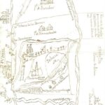
Abstract: The image shows a plan-drawing of the Nuevas Poblaciones de Sierra Morena in the 18th century. Extensions of the municipal district of Hornachuelos (Córdoba) are depicted.
Image
Tags


