
Geographical map of the Iberian Peninsula, with the division of Portugal and Spain, and the internal royal divisions, by Tomás López, which forms part of the Geographical Atlas of Spain published by the author’s sons in 1804, compiling various cartographic works by his father.

Edad Moderna
Geographical map of New Spain, in present-day Mexico. Factitious title taken from another manuscript copy of Humboldt’s original: “Carta geográfica general del reino de Nueva España, sacada de la original hecha en 1803 por el Sor. Baron de Humboldt and dedicated to the Count of Valenciana. It is one of the contemporary manuscript copies made of Humboldt’s original in Mexico City in 1804.
Reproduction made in 1992 of the Universal Letter handwritten by Juan de la Cosa in 1500, on the occasion of the V Centenary of the Discovery of America, which is kept in the Naval Museum of Madrid (Sign. 257). Edition of 2,000 copies.
Anonymous world map, probably made in the 18th century
It is part of a petition and evidence of the cities of Guadalajara, Purificación, Zacatecas, mines of Tepeque (Bolaños), Etzatlán, Guachinango and Llanos de los Chichimecas (Lagos), on their behalf and on behalf of the conquerors and settlers of New Galicia presented before the oidor and visitador general Hernando Martínez de la Marcha on 10 January 1550 requesting the transfer of the seat of the diocese and the Audiencia from the city of Compostela to that of Guadalajara.
Map of the kingdom of Navarre in the 17th century.
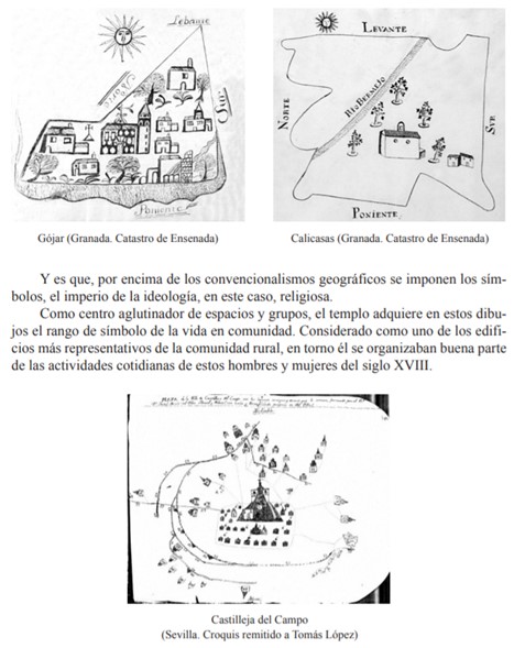
Resource showing the municipal representation highlighting the Church as a central element, reflecting the religious mentality expressed in local symbols
Division into archdioceses, dioceses, archpriestships and parishes in Spain
Everyday life, celebrations and religious festivities. The image shows the representation of a Tarasca from the Corpus Christi procession
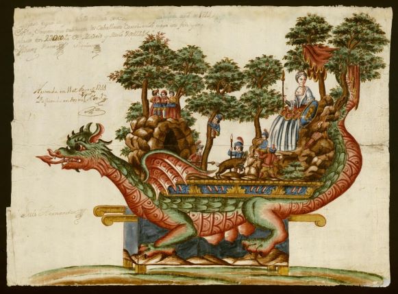
Everyday life, celebrations and religious festivities. The image shows a Tarasca for the Corpus Christi procession of 1744 in Madrid
Page 2 of 6

