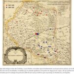
The Kingdom of Cordoba was one of the territories involved in the great plague epidemics that devastated the Iberian Peninsula during the 17th century. The resource lists the localities affected, using the 1761 map drawn up by Tomás López. In red are the epidemic outbreaks that occurred in the two-year period 1649-1650. Originating in the ports of Cadiz and the cities of Seville, Malaga, Antequera and Murcia, the epidemic reached the city of Cordoba with virulence and affected the municipalities located in the north of the kingdom and some areas in the south. Years later, and represented in blue dots, another plague epidemic broke out, which had a greater incidence in the south and, once again, in the city of Cordoba itself. How did the kingdom’s authorities deal with the epidemics? Isolation and the closure of communications were the best way to prevent the plague from spreading further; however, the absence of a centralised entity to control and delimit the vast territories resulted in the permeability of municipal borders. At the local level, the Board of Health decreed the measures to be implemented: food stockpiling, closure of trade, limitation of foreign trade and promotion of hygiene were the most widespread formulas.
Collection: Images
Project: 3. Rural world and urban world in the formation of the European identity., 4. Family, daily life and social inequality in Europe.
Chronology: XVII
Scope: Secondary Education, Baccalaureate, University
Resource type: Image
Format: Map
Source: Olmedo Granados, F. y García León, G. J. (2021). Andalucía y la cartografía histórica de las pandemias. Sevilla: Fundación Pública Andaluza Centro de Estudios Andaluces, p. 57.
Language: Spanish
Date: 1761
Owner: Pablo Ballesta Fernández (Modernalia)
Copyright: ©Fundación Pública Andaluza Centro de Estudios Andaluces ©Fernando Olmedo Granados ©Francisco Javier García León
Abstract: Map showing the distribution of plague in the former Kingdom of Cordoba during the 17th century
Image
Tags


